
Geographical Location of Jaipur
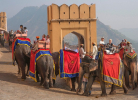
Jaipur, The Pink City is the capital city of the desert state Rajasthan, India. Jaipur was founded by Maharaja Sawai Jai Singh II on 18 November 1727 and was named after its founder. It is located in the east border of Thar Desert which is the only desert of India. In western direction it shares a common international boundary of mesmerizing and mysterious desert with Pakistan.
Surroundings
Jaipur is situated at an altitude of 431 meters / 1417 feet above the sea level, resulting in a semi arid climate with relatively high temperatures throughout the year. Enclosed by Aravalli Hills from three sides, Jaipur is rich in panoramic beauty that attracts tourists from all over the world. These hills also guard Jaipur from the rough and dry climate of the desert region. Sikar district is situated to its north and Tonk is in south direction. Eastern boundary touches Alwar district, while Nagaur, Ajmer cities are located in the Western side of Jaipur.
Dimensions
The total area of Jaipur city is 4292. 6sqmt measuring 180 kilometers from East to West and 110 kilometers from North to South. The grand city with royal heritage has a population of nearly 3.1 million and is known to be one of the well planned city of India. The city is planned in accordance with the grid method of construction following the rules of Vastu Shastra for harmony and prosperity of its citizens.
The colorful city is just 260 kilometers from Delhi, the capital city of India. One can enjoy the royal stay and experience the splendid culture of Jaipur, The Pink City.